
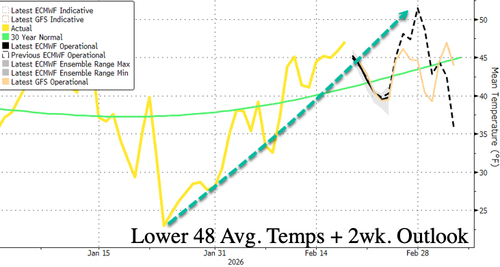
Meteorologists on X are posting new weather models showing a setup for a potentially serious winter storm threat that could blanket parts of the Mid-Atlantic and Northeast with wintry precipitation from Sunday into Monday. The elevated risk of a major snow threat is notable because the peak of Northern Hemisphere winter in the Lower 48 has already passed and temperatures have been trending higher.
A major storm threat from Sunday into Monday could bring significant winter precipitation from Washington, DC, to Philadelphia, to New York City, and to Boston.
Just a few hundred miles could make the difference between heavy snow in the Mid-Atlantic and Northeast on Sunday and Monday — or none at all.
— Ben Noll (@BenNollWeather) February 19, 2026
As the forecast comes into focus, the latest probabilities show a medium chance for 3+ inches in a stretch from D.C. to Boston. pic.twitter.com/1A7xa826iu
"As the forecast comes into focus, the latest probabilities show a medium chance for 3+ inches in a stretch from D.C. to Boston," Noll said.

An excerpt from meteorologist Ryan Maue's weather note outlined the increasing chances that a nor'easter/coastal storm will develop and impact the Mid-Atlantic and Northeast by late weekend.
Maue wrote:
East Coast Storm System — Mid-Atlantic + Nor'easter Watch
Updated ECMWF 06z shows the low-pressure center waiting to rapidly intensify or "bomb out" until late Sunday into Monday, missing the opportunity for the backside of the circulation to dump snowfall on the coast. The northeast track keeps the low-pressure center away from New England as well.
Ensembles: The ECMWF EPS at 06z (median) still NOT interested in the coastal storm having major impacts to the Mid-Atlantic or the Northeast.
Ensemble Probability of 3 inches of snow: about a coin flip from Washington, D.C., to Philly and New York City


The question is whether cold air will be in place as the storm arrives in the Mid-Atlantic region by late weekend. If so, plan accordingly for any travel disruptions.


